+1 866 300 9012   contact@measur.ca
SHOPPING CART

No Products in the Cart

TOTAL:
$0.00

Written by: Maria Zavarce

Contributor: Lukas Wilgosh 

DJI Welcomes the New Year with the Matrice 4 Series

January 14th, 2025

3 minutes read

DJI has done it again. Known for setting the bar in drone innovation, they’ve welcomed the new year 2025 with a leap forward - the Matrice 4 series. This latest lineup combines cutting-edge imaging, intelligent features, and high performance, making it a game-changer for industries that leverage drones to get the job done.


From public safety and search and rescue to infrastructure inspections and mapping, the Matrice 4 series is built to tackle some of the toughest challenges with ease. Let’s take a closer look at what makes these drones the beginning of the intelligent flight.


The Matrice 4 series introduces two models that are purpose-built for professionals across a range of industries:

DJI Matrice 4E

Cameras Built for Geospatial Applications

The Matrice 4E is built for precision in surveying and mapping. Its wide-angle camera (4/3 CMOS, 20MP) captures sharp, distortion-free imagery with an adjustable aperture (f/2.8–f/11) and mechanical shutter, perfect for large-area orthomosaics. The medium tele camera (1/1.3" CMOS, 48MP) bridges wide and long-range perspectives, ideal for mid-range details like structural assessments. For distant targets, the tele camera (1/1.5" CMOS, 48MP) provides crisp, long-range imaging with its 168 mm equivalent lens.


A laser range finder completes the system, measuring distances up to 1,800 m with exceptional accuracy for terrain analysis and 3D modelling. 

DJI Matrice 4E

$6,229.00 CAD

Learn More

DJI Matrice 4T

Emergency and Public Safety Precision

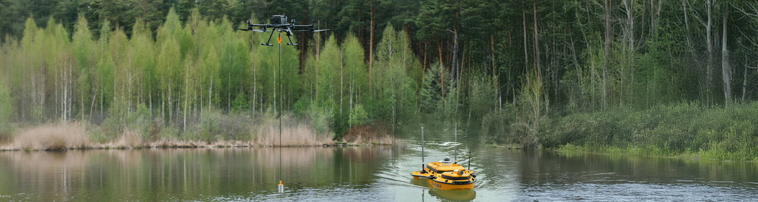
The Matrice 4T is designed for excellence in critical response scenarios, building upon the powerful capabilities of DJI's previous Mavic 3 series. In fact, the new Matrice 4 series is so advanced compared to the Mavic 3 series that DJI made the decision to name it the Matrice 4 series, instead of the expected Mavic 4 series. This change reflects the significant technological leap and the specialized features designed for more complex and demanding operations.


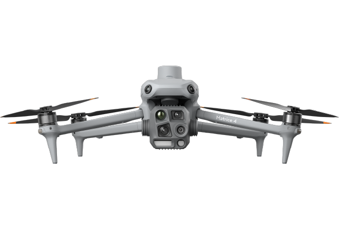
The wide-angle camera (1/1.3" CMOS, 48MP) captures expansive, high-resolution visuals, while the medium tele camera (1/1.3" CMOS, 48MP) zooms in on mid-range details for better scene analysis. The tele camera (1/1.5" CMOS, 48MP) with a 168 mm equivalent lens enables precise imaging of distant objects, adding greater versatility to the drone’s capabilities.


Taking a step forward from the Mavic 3 series, the Matrice 4T now includes the 3x Tele, 7x Tele, Laser Range Finder, and NIR Auxiliary Lighting, features previously unavailable in the Mavic 3 thermal.


The laser range finder provides distance measurements up to 1,800 m, ensuring high accuracy and supporting situational awareness and mission planning. The infrared thermal camera with a 640x512 resolution proves essential for heat signature detection. The NIR Auxiliary Light adds an impressive 100 m of illumination, enabling reliable operations in low-light and nighttime conditions.

DJI Matrice 4T

$9,439.00 CAD

Learn More

AI and Intelligent Features

A great and new feature that hasn’t been seen before in DJI drones is the integration of advanced AI and intelligent capabilities within the Matrice 4 series, such as:


• Real-Time Object Detection: This AI-powered feature automatically detects and tracks people, vehicles, and boats, which streamlines operations in critical public safety scenarios, such as search and rescue or law enforcement.


• Cruise Observed View: Similar to cruise control in a car, this feature allows the drone to maintain a consistent speed during patrols and routine inspections, reducing the need for constant manual control.


• Smart 3D Capture: With this tool, the Matrice 4 series can quickly generate rough 3D models of structures or terrain, perfect for inspections, mapping, and creating digital twins.

These AI-driven innovations help reduce the operational workload while significantly boosting the overall efficiency of missions.

Performance Improvements Over the Mavic 3E Series

In demanding situations where reliability and speed are crucial, the Matrice 4 series delivers impressive upgrades compared to DJI's previous compact yet powerful Mavic 3E series. The table below highlights the significant improvements:

Feature Matrice 4 Series Mavic 3 Series Improvement
Transmission Range 25 km / 15 miles 15 km 66% increase
Max Ascent Speed 8 m/s / 18 mph 6 m/s 33% increase
Max Forward Speed 21 m/s / 47 mph 15 m/s 40% increase
Flight Time 49 minutes 43 minutes 6 minute increase

Safety Features

The Matrice 4 series is designed with safety in mind, ensuring confidence even in high-stakes environments. With 360° obstacle avoidance, fisheye cameras monitor every angle of the drone, preventing collisions in low-visibility conditions. The advanced sensing system is also capable of detecting thin objects, such as wires and small obstacles, making it more reliable in complex environments. Additionally, the drone comes preloaded with terrain data, allowing operators to plan ahead by loading maps of the terrain and obstacles before the mission starts. Together, these safety features make the Matrice 4 series a safe and dependable choice for any operation.

D-RTK 3 Multifunctional Station

DJI has also introduced the new D-RTK 3 Multifunctional Station, a high-precision GNSS system designed to deliver exceptional positioning accuracy and enhanced operational capabilities. This advanced accessory is engineered to support demanding applications, offering centimeter-level positioning accuracy. It supports multiple drones in base station mode, extends operational range in relay station mode, and provides high-precision aerial surveying in rover station mode when paired with DJI Enterprise app and DJI Terra.

Get in Touch

Give us a call or drop by anytime, we will answer all enquiries within 24 hours on business days. We will be happy to answer your questions.

About the Author

Maria Zavarce, Marketing Coordinator at Measur, brings over two years of specialized experience in the drones and robotics industry. Combining her knowledge of emerging technologies with 8+ years of inbound marketing and SEO, she provides actionable insights into the transformative power of advanced solutions.

YOU MAY ALSO LIKE

Bathymetric surveys, which involve mapping the underwater topography of lakes, rivers, oceans, and other bodies of water, have historically been conducted using traditional manned boats equipped with sonar systems. While effective, these methods can be time-consuming, expensive, and sometimes risky, especially in shallow, remote, or hazardous waters. However, drones or unmanned aerial vehicles (UAVs) and unmanned surface vessels (USVs) are facilitating bathymetric surveys by offering a faster, more efficient, and safer alternative.

What is a bathymetric survey?

A bathymetric survey measures the depth and topography of the underwater surface, providing a detailed map of the waterbed. These surveys are essential for a variety of industries, including environmental monitoring, coastal engineering, underwater construction, and scientific research. Traditional methods often rely on echo sounders mounted on boats or ships, but drones now offer new possibilities for bathymetric data collection.

Types of Drones Used for Bathymetric Surveys

There are two primary types of drones used in bathymetric surveys, Aerial Drones (UAVs) and Surface Drones or USVs:

Aerial Drones (UAVs)

Drone-Based Echo Sounder
EchoLogger ECT D052S Echo Sounder
These drones are typically used to collect aerial data or to assist in launching smaller surface drones. They can also be equipped with LiDAR sensors or photogrammetry systems to map the water surface. For example, the DJI M350 RTK, can be outfitted with devices like the EchoLogger ECT D052S, a high-performance dual-frequency echo sounder that measures water depths between 0.5 to 200 meters. This echo sounder comes equipped with tilt and temperature sensors and features an RS232 interface, allowing easy integration with drones. Its lightweight and durable design make it ideal for deployment in challenging environments, offering accurate underwater data collection for small to large-scale water bodies. The echo sounder provides a versatile, efficient solution for detailed underwater mapping without the need for traditional manned vessels.
Oct 01, 2024
BACK TO TOP