No Products in the Cart
The TrueView 720 is a high-performance 3D imaging system optimized for corridor and infrastructure mapping applications. Integrating three RIEGL lidar scanners and multi-angle camera coverage, it delivers dense, high-fidelity geospatial data in a single flight line. Designed for maximum efficiency and accuracy, the system supports advanced modelling of complex environments.
|
LiDAR Range |
Returns |
Total RGB |
Pecision |
720m |
Up to 32 |
3 x 20 MP
|
5 mm |
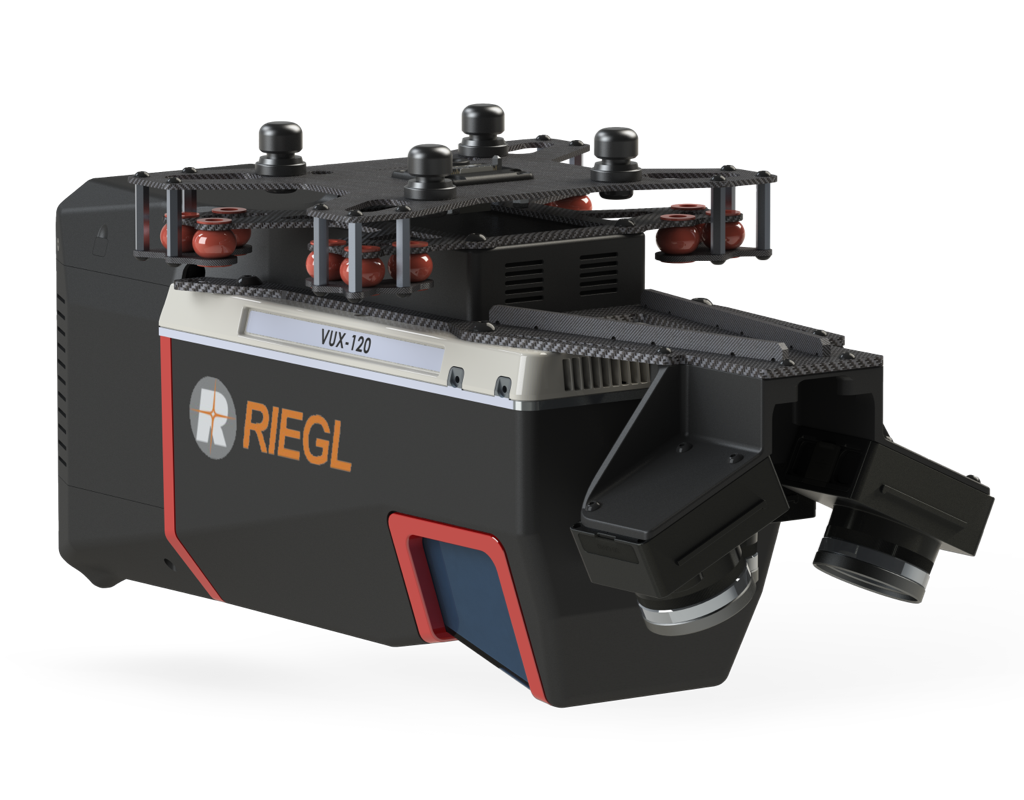
High-Density Data Acquisition with Angular CoverageThe TrueView 720 integrates the RIEGL VUX-120 with three lidar scanners configured for nadir, +10° forward, and -10° backward orientations, enabling comprehensive point cloud capture from multiple angles. This configuration is engineered for detailed 3D reconstruction of linear assets such as power transmission lines, rail corridors, and pipelines. Paired with a tri-camera imaging system, the platform collects high-resolution oblique and nadir imagery in a single flight path, supporting advanced photogrammetric modelling and feature extraction with full vertical and lateral context. |
|
|

| Feature | Details |
|---|---|
| Data Collection | LiDAR + Imagery |
| Laser Scanner |
RIEGL VUX-120 |
| LiDAR Beams / Returns |
Up to 32 |
| LiDAR Range - usable | 720 m for targets with > 20% reflectivity |
| Positioning and Orientation System |
Applanix APX-20, ask for other IMU options available |
| Pulse Repetition Rate |
Up to 2.4 Mhz (selectable) |
| Scanner Precision |
Precision: 5 mm |
| Scanner Accuracy |
Accuracy: 10 mm |
| GNSS/INS Position Accuracy |
Position: 20-50 mm Angle: 0.015 deg Roll/Pitch, 0.035 deg Heading |
| System Performance | Precision observed on one Strip: Typical 10 mm, Less than 10 mm (1 sigma) observed at 80 m on concrete Accuracy: Typical 3 cm RMSE, better than 5 cm 3D RMSE – depending on GNSS conditions, accuracy of control points and coordinate system |
| Camera Sensor | Triple 1” sensor with mechanical shutter, hardware mid-exposure pulse, 60 MP combined, RGB. Ask for further custom camera integration. |
| Mass | 3.4 kg (payload unit only - no accessories including battery, mount, antenna, power adapter) |
| System Operation Temperature Range | -10° to 40° C |
It integrates seamlessly with major drone platforms such as:
DJI. Inspired Flight, Skyfront. Freefly, Wispr, Harris Aerial, XER
TrueView 3D imaging Sensors are designed and manufactured in our Huntsville, Alabama, USA facilities.