No Products in the Cart
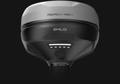
The Reach RS4 can track all available satellite constellations and frequencies, including the lower L5 and L6 bands, which are more resistant to multipath and interference. With 672 channels, it can track 40+ satellites at a time. These features ensure reliable performance and centimeter-level precision.
7mm + 1ppm in RTK
672 channels
L1/L2/L5/L6
Fix in under 5 seconds
GPS, GLONASS, Galileo, BeiDou, QZSS, NavIC
16 hours
on one charge
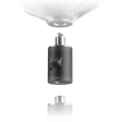
Magnesium Alloy body
offers exceptional strength
-40°C To +60°C
Operating Temperature
IP68
Protection Rating
The Reach RS4 comes with Emlid Flow, a comprehensive mobile and cloud solution compatible with both iOS and Android. It keeps your team aligned and your projects on track while supporting various site tasks.
Transmit and receive
Up to 2W (may require a license)
Compatible with Reach and 3rd-party receivers with TRIMTALK 450S support
Transmit and receive
Up to 1W (license-free in North America)
Compatible with Reach receivers

Invite team member, share projects, manage access
Monitor field progress from the office and exchange data instantly
One workflow for the whole team, with data that is always up to date, a consistent interface, and no additional training required
Topographic surveys - gather terrain and elevation data accurately
Line & road surveys - stake centerlines and offsets with precision
As-built verification - check constructed structures against your plans
Stakeout & layout: place points, lines, and markers directly in the field
Cut & fill calculations: measure earthworks and stockpiles on site
Give us a call or drop by anytime, we will answer all enquiries within 24 hours on business days. We will be happy to answer your questions.
We would love to hear from you! Our team is always here to help.
+1 866 300 9012
contact@measur.ca
Vancouver, British Columbia
Calgary, Alberta
Mississauga, Ontario
Montreal, Quebec