No Products in the Cart
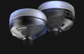
The Reach RS4 Pro delivers centimeter-level accuracy, even in challenging environments like forests or urban canyons. With support for every GNSS constellation and signal frequency, including the L5 and L6 bands, resistant to multipath and interference, the Reach RS4 Pro locks onto 40+ satellites simultaneously using 672 channels.
7mm + 1ppm in RTK
672 channels
Full-band support: L1/L2/L5/L6
Fix in under 5 seconds
GPS/ GLONASS, Galileo, BeiDou, QZSS, NavIC
16 hours
on one charge
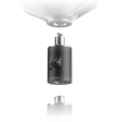
Magnesium Alloy body
offers exceptional strength
-40°C To +60°C
Operating Temperature
IP68
Protection Rating
The Reach RS4 Pro is powered by Emlid Flow—a complete field and cloud solution for iOS and Android. From initial setup to final verification, Emlid Flow keeps your entire team connected, your data synchronized, and your project on track.
Dynamic navigation
Auto bullseye View
Cut & fill indicator
Quick point switch
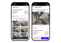

Invite team member, assign roles, and share projects
Monitor field progress from the office and sync data instantly with the field
Unified workflows for all team members, consistent interface, no extra training needed
Topographic surveys: capture precise elevation and terrain data
Line & road surveys - stake centerlines and offsets with precision
As-builts: confirm construction accuracy against design plans
Stakeout & layout: mark points, lines and site boundaries
Cut & fill calculations: measure stockpiles and earthworks on-site
Give us a call or drop by anytime, we will answer all enquiries within 24 hours on business days. We will be happy to answer your questions.
We would love to hear from you! Our team is always here to help.
+1 866 300 9012
contact@measur.ca
Vancouver, British Columbia
Calgary, Alberta
Mississauga, Ontario
Montreal, Quebec