No Products in the Cart

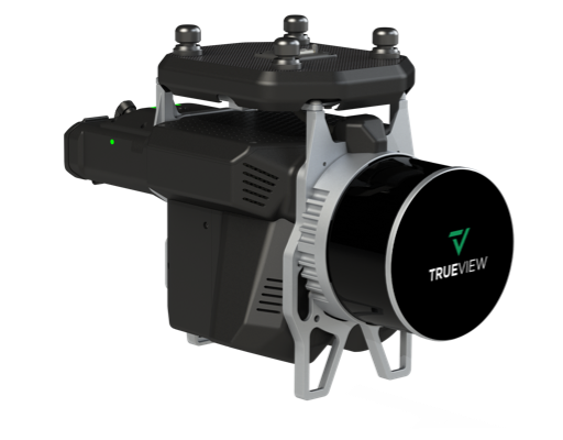
GeoCue TrueView 515 is a high performing mid-range LiDAR/camera system. Now enhanced with Version C’s Dual 26 MP Oblique Cameras, this compact, all-in-one 3D imaging payload delivers exceptional performance in wire detection, vegetation penetration, and ground definition.
|
Precision |
Weight |
LiDAR Scanner |
LiDAR Range |
5 mm |
1.99 kg |
Hesai Pandar XT32M1X
|
|
Direct ColorizationGeoCue’s custom integration of dual cameras with the LiDAR system to allow ray-tracing, which achieves direct colorization for a more accurate point cloud representation. |
|
|

TrueView 515 isn’t limited to airborne operations. For users facing flight restrictions in urban areas or needing diverse perspectives, the system can also be deployed in mobile mapping mode using an optional vehicle mount. This dual-use capability provides a significant operational advantage and allows teams to maximize the utility of a single system across varied environments.
| Feature | Details |
|---|---|
| Data Collection | LiDAR + Imagery |
| Laser Scanner | Hesai Pandar XT32M1X |
| LiDAR Beams / Returns | 32 / 2 |
| Usable Range | 80 m @ 20% reflectivity |
| Field of View (FOV) | 120° Cross-track |
| Pulse Repetition Rate | 640 kHz |
| Scanner Precision | 5 mm |
| Scanner Accuracy | 20 mm |
| GNSS/INS Position Accuracy | 20–50 mm |
| GNSS/INS Angle Accuracy | 0.025° Roll/Pitch, 0.08° Heading |
| System Accuracy | Typical 3 cm RMSE; < 5 cm 3D RMSE |
| System Precision (One Strip) | Typical 20 mm; < 15 mm (1σ @ 75 m) |
| Camera Sensor | 2 × 26 MP Sony mechanical leaf shutter, calibrated |
| Mass | 1.99 kg (payload only, no accessories) |
| Software Included | LP360 Drone with Strip Align and Photo Add-ons |
The TrueView 515 is a highly capable system ideal for applications such as:
• Topographic mapping in vegetated environments
• Coal pile volumetrics and inventory management
• Inspection of vertical structures such as buildings, bridges, and towers
• Mapping in constrained or populated areas using mobile deployment
Each TrueView 515 package comes with everything needed to begin high-quality 3D data collection and processing:
• TrueView 515 LiDAR/Camera Payload
• GNSS Antenna
• Battery and Charger
• USB Thumb Drive
• Rugged Sensor Hardcase
• LP360 Drone Software (with Strip Align and Photo Add-Ons)
• 1-Year Hardware and Software Support
It integrates seamlessly with major drone platforms such as:
DJI. Inspired Flight, Skyfront. Freefly, Wispr, Harris Aerial, XER
TrueView 3D imaging Sensors are designed and manufactured in our Huntsville, Alabama, USA facilities.