No Products in the Cart

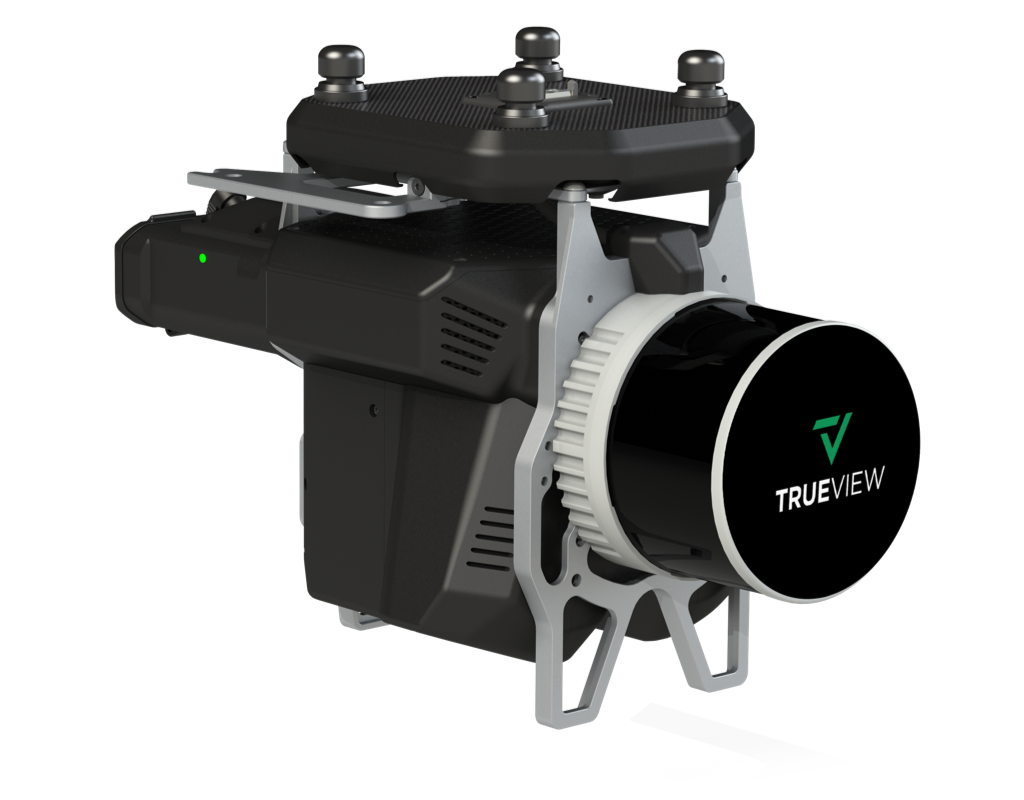
Building on the success of the TrueView 515, the TrueView 535 introduces enhanced capabilities for vegetation modeling, photogrammetry, and dual-platform deployment. Now with a third LiDAR beam return and an advanced triple-camera configuration, the TrueView 535 delivers high-accuracy results from the air or the ground.
|
Precision |
Weight |
LiDAR Scanner |
LiDAR Range |
5 mm |
1.75 kg |
Hesai XT32M2X
|
|
New in TrueView 535 Version C
• Dual Oblique + One Nadir 26 MP Cameras for high-quality photogrammetry deliverables • Optional Mobile Mapping Mode for flexible ground data collection • FLEX Pricing Model available – budget-friendly access with subscription-based software
|
|
|

For users facing flight restrictions in urban areas or needing diverse perspectives, the system can also be deployed in mobile mapping mode using an optional vehicle mount. This dual-use capability provides a significant operational advantage and allows teams to maximize the utility of a single system across varied environments.
| Feature | Details |
|---|---|
| Data Collection | LiDAR + Imagery |
| Laser Scanner | Hesai Pandar XT32M2X |
| LiDAR Beams / Returns | 32/3 |
| Usable Range | 120 m @ 20% reflectivity |
| Field of View (FOV) | 120° Cross-track |
| Pulse Repetition Rate | 640 kHz |
| Scanner Precision | 5 mm |
| Scanner Accuracy | 20 mm |
| GNSS/INS Position Accuracy | 20–50 mm |
| GNSS/INS Angle Accuracy | Angle: 0.025 deg Roll/Pitch, 0.08 deg Heading |
| System Accuracy | Typical 3 cm RMSE, better than 5 cm 3D RMSE – depending on GNSS conditions, accuracy of control points and coordinate system |
| System Precision (One Strip) | Precision observed on one Strip: Typical 20 mm, Less than 15 mm (1 sigma) observed at 75 m on concrete |
| Camera Sensor | 3 × 26 MP Sony mechanical leaf shutter, calibrated |
| Mass | 1.75 kg (payload only, no accessories) |
| Software Included | LP360 Drone with Strip Align and Photo Add-ons |
The TrueView 535 is a highly capable system ideal for applications such as:
• Topographic mapping in vegetated environments
• Coal pile volumetrics and inventory management
• Inspection of vertical structures such as buildings, bridges, and towers
• Mapping in constrained or populated areas using mobile deployment
Each TrueView 535 package comes with everything needed to begin high-quality 3D data collection and processing:
• TrueView 535 LiDAR/Camera Payload
• GNSS Antenna
• Battery and Charger
• USB Thumb Drive
• Rugged Sensor Hardcase
• LP360 Drone Software (with Strip Align and Photo Add-Ons)
• 1-Year Hardware and Software Support
It integrates seamlessly with major drone platforms such as:
DJI. Inspired Flight, Skyfront. Freefly, Wispr, Harris Aerial, XER
TrueView 3D imaging Sensors are designed and manufactured in our Huntsville, Alabama, USA facilities.